

A federal tax law first passed in 2017 that helped spark a wave of new development was renewed last year, and cities across Utah are in the process of updating the boundaries that could hint at where the next wave of development could occur.
During a meeting Tuesday, members of the Salt Lake City Council were briefed on potential changes to the city’s opportunity zones — which are typically low-income areas of a city where investors can receive breaks on capital gains taxes if they choose to invest in new construction within the zone.
Opportunity zones (OZs) were created as part of the Tax Cuts and Jobs Act of 2017, and city officials will need to send a refreshed opportunity zone map and list of prioritized areas to the Utah Governor’s Office of Economic Development before June 10.
Here’s how it works: those investing into OZ’s can roll their capital gains into a Qualified Opportunity Fund (QOF) and defer taxes on those gains, as well as get partial reductions in that deferred tax if they hold onto the investment. If investors hold that investment for at least 10 years, any gains from the QOF could be tax-free.
Lorena Riffo-Jenson, the city’s economic development director, explained this concept to the council during a meeting Tuesday, as well as the goals for the updated round of OZs.
“Because there has been some criticism in terms of the rules and administration, the federal government opportunity zone 2.0 now has narrowed and tightened those rules to focus in low-income tracts, reward long-term investment in real businesses, require local hiring and anti-displacement measures, sets anti-abuse checks, and improve public reporting,” Riffo-Jenson said Tuesday.
Colin Gibbs, the city’s business development director, said the city could pick seven areas. The draft map shows the updated areas include the Ballpark neighborhood, as well as parts of Poplar Grove and Glendale, among others.
Nick Norris, the city’s planning director, later clarified that the areas are divided by census tract, meaning some areas could be larger or smaller but are ultimately mapped via population.
Once finalized, the areas will provide tax benefits between January 2027 and the end of 2036, meaning the areas chosen could become magnets for development in the run-up to Salt Lake City hosting the 2034 Winter Olympics.
Gibbs said part of the city’s decision making process focused on certain industries, which he said include “tech, aerospace and defense, fintech, life sciences, energy, and minerals.”
He added the city also focused on long-term commitments that align with, “the 2034 Olympics and industries in proximity to the venues, also transit corridors and hospitality hubs.”
While some of the OZs are similar to those in the past, the new map reflects some of Salt Lake City’s changes in the last decade.
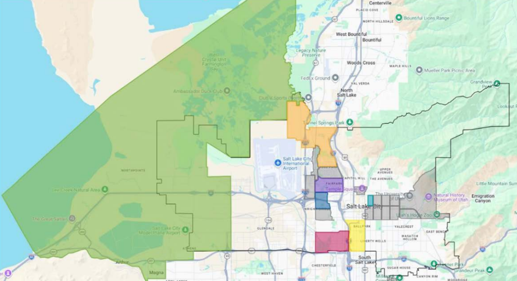
The map of new opportunity zones around Salt Lake City. Areas highlighted in color would be designated opportunity zones, while areas highlighted in gray are eligible areas that were not selected by city officials as opportunity zones. Image via Salt Lake City
For example, the last OZ map included nearly all of Downtown and much of the Granary District — and the latter is nearly unrecognizable from what it was around 10 years ago. As the Granary continues its buildout, both that district and Downtown would no longer be OZs in the updated map.
The city’s top pick for a new OZ is Ballpark, which wasn’t included in the previous list. That census tract runs from 900 South to 2100 South, as well as from Interstate 15 to State Street. Another new OZ in the proposed map is a portion of Glendale. The census tract would run from Redwood Road to I-15, as well as from California Avenue to Highway 201.
An administrative transmittal attached to council materials Tuesday says that section of Ballpark is an ideal OZ location, as the area features, “permissive zoning, development potential, support of target industries, transit access, and ability to access 2034 Olympic venues by transit.”
“The entire 300 West Corridor between I-15 and 200 West is zoned MU-11, which is the most intense mixed use zone in the city outside of the downtown area and allows life sciences, financial services and other uses that could support Quantum computing, research and development, and AI as a ‘research and development facility,’” the transmittal says.
With the city’s plan to overhaul Smith’s Ballpark into a mixed-use neighborhood hub, being designated an OZ could also spur further development in the area. The neighborhood has a number of parcels ripe for redevelopment, and an OZ designation could speed up investments into the community.
Council Member Erika Carlsen, who represents Ballpark, said the neighborhood would be a prime space to drive economic growth, adding, “I’m excited to see if this moves forward greater economic development and investment into that part of the city.”
The city’s list was chosen from a list of eligible OZ areas created by the governor’s office.
Another highly-ranked area for an OZ is labeled as Poplar Grove North/Power District, and the same tract was included in the previous OZ list.
Council Member Victoria Petro questioned if an area like the Power District, which is already slated for heavy redevelopment in the coming years, should have the OZ tag, asking if this was another instance of tax benefit that would be drawn away from the area — something she’s been outspoken about previously.
“I’m just wondering if this is our best use of (OZs) when we could allow the existing state taxation structure to handle the benefits to those developers, and maybe we pay attention to other areas that we would like to see things that will return the benefit directly to our city,” Petro said.
Riffo-Jenson said her office took that into consideration while mapping potential OZs. She said her office thought about where development could be maximized over the next 10 years, and economic development also talked with local stakeholders to help inform their maps as well.
Rachel Otto, chief of staff in the mayor’s office, also spoke to Petro’s question. She said the Governor’s Office of Economic Development encourages cities to pick OZs with the help of state and county governments, as well as local developers.
“There’s obviously a lot of energy and making sure that these areas receive development potential, and so that factored into our analysis and our ranking,” Otto said.
The council did not vote on the maps, as the talk was only an informational briefing. Salt Lake City must submit the OZ map to the state government by June 10, which is the statewide deadline.








0 Comments